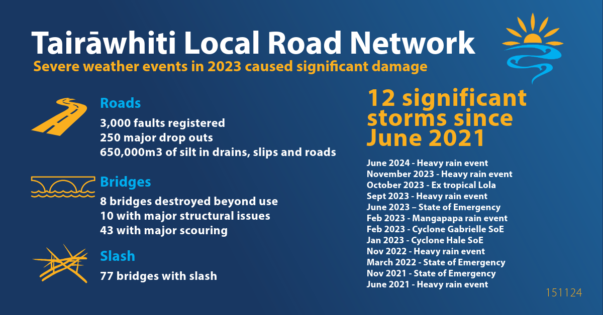
In 2023, our local roading network was severely impacted by Cyclones Hale and Gabrielle. Almost all rural roads were closed, leaving communities cut off for weeks. The damage was extensive with 8 bridges destroyed, 54 bridges sustained major damage and there were numerous slips and dropouts affecting key routes. The scale of destruction has left a recovery bill stretching into the hundreds of millions of dollars.
The total cost to restore our local roading network to its pre-cyclone condition has been assessed at $465 million. But to build back stronger and more resilient, we need $725 million. So far, we've received $245 million in funding, with an additional $85 million for the initial emergency response costs.
Our focus remains clear - to reopen roads for isolated residents, restore access for heavy freight to support our rural communities and prioritise school bus routes, safe community connections, and forestry and farm access - especially where animal welfare is at risk.
The funding of projects
- $76.7m on destroyed bridges - fixing 4 bridges with the government funding.
- $23m on 65 damaged bridges.
- $1m on minor repairs to 35 bridges
- $45m Tiniroto Road - investigation and construction of bypass across the Hangaroa River before the first bluff and back over the river after bluff 2.
- $51.8m to fix major slips and dropouts
- $36m working in partnership with iwi on projects to provide greater resilience to communities
Bridge repairs or replacement
We assessed all 424 bridges in our region following Cyclone Gabrielle:
- 6 bridges were destroyed
- 65 bridges required major repairs
- 35 required minor repairs to ensure their resilience in future severe weather events.
- 32 bridges were also damaged in severe weather events prior to, or post Cyclone Gabrielle
Tiniroto Road - Hangaroa Bluffs
Tiniroto Road at the Hangaroa Bluffs sustained major damage at the bluffs following Cyclone Gabrielle. Around 1.4km of road was undermined, with river protection works either partially or completely destroyed. The 2 lane road was scoured away, leaving less than one lane in some sections. Repairs included rebuilding retaining wall structures and restoring rock protection. The road was initially reopened to single-lane access.
However, recurring weather events continued to destabilise the area, causing further scouring and rockfall risk. In June 2023, the road was closed due to the danger of falling rocks. After 10 months of extensive repair and stabilisation work, the road reopened.
Tiniroto Bluffs reports
- June 2023 Tiniroto Road Site Inspection Report by LDE
- July 2023 Addendum to the Inspection Report - Risk Mitigation Options and Costs
In October 2024, following detailed engineering investigations and with $45M in government funding, a long-term solution was confirmed: a bypass was identified as the most suitable and resilient solution for the area.
Slips and dropouts
As part of Phase 4 of the recovery programme, $51.8m has been allocated to repair slips and dropouts that met the funding criteria. This is jointly funded by $40.5 million from NZTA and $11.3 million from the government.
Progress to date
- Phases 1 and 2: 19 sites - works completed in 2023
- Phase 3: 43 sites - works completed in 2023
- Phase 4: 343 sites - works began October 2024
- 246 sites completed by July 2025
Site selection criteria
Slips and dropout were prioritised based on:
- Current impact on the level of service
- Regional economic importance of the route
Lavenham Road dropout repair
As part of the local roading recovery programme, this 125-day construction project involved a team of 6 installing 30 steel piles (12m high) placing 230m3 of backfill, 175m3 of rock armouring and 70m of new guard rail on the Lavenham Road droupout that took out half the road carriage.
$51.8m has been allocated to fix major slips and dropouts across our local network following cyclones Hale and Gabrielle and other severe weather events in 2023. Jointly funded by NZTA and the government's recovery support package for Tairāwhiti.
Roadside drainage - supporting iwi communities
A $36.9 million phased programme to strengthen key local roads identified by iwi and community stakeholders. These routes are critical for emergency access, maintaining cultural connections and everyday travel across the region.
Phase 1: 132 sites completed January - June 2025
This phase focused on improving surface conditions and drainage on roads used as alternative routes when state highways are temporarily unavailable.
Roads included Whakarau, Te Wera, Waimata Valley Road, Hokoroa, Tahora, Armstrong, Ihungia and Tuakau roads.
Works completed:
- 121.5km of drainage cleared
- 74 culverts repaired
- 15 dropout and road widening sites
- 7 slips
- 4 pavement repairs
Phase 2: 150 sites completed October 2024 - April 2025
This phase prioritised roads providing sole access to remote or vulnerable communities, including areas of cultural significance.
Roads included Anaura, Makarika, Rangitukia, Waimomatatini, Tapuaeroa, Kopuaroa, Waingake and Whatatutu roads.
Works completed:
- 24.5km of drainage cleared
- 76 culverts repaired
- 206 culverts cleared
Phase 3: October 2026 - June 2027
Complex sites requiring detailed engineering design
This phase focuses on larger, more complex projects identified in partnership with iwi as priorities to improve evacuation routes and access to vulnerable communities and culturally significant sites. Additional routes across the region are also being assessed.
Key projects include:
Coates Corner
Raising the road to allow floodwaters to pass underneath, reducing overtopping during severe weather.
Construction: October 2026 - March 2027
Tokomaru Bay seawall
Rebuilding the seawall to better protect the road and surrounding community from king tides and coastal impacts.
Construction: October 2026 – June 2027
Tapuaeroa Road
Raising a key section of the road and improving drainage to strengthen resilience during severe weather and king tides.
Construction: October 2026 – March 2027
Site selection criteria
Sites and routes were prioritised by iwi using the following criteria:
- current impact on level of service
- cultural importance of the location or destination
- regional economic importance of the route
- evacuation restrictions in case of emergency
- school bus route access
Waihau Road
In the June 2023, a significant landslide washed out part of Waihau Road, approx 4.8km from the intersection with SH35. Geotechnical engineers inspected the site, where 5m of the road had been lost, and confirmed it was part of a much larger 110m fault.
The dropout was caused by a landslide and debris flow originating more than 30m above the road. The debris overwhelmed the road, blocked drainage systems and led to flooding what washed out the road surface. For a time, residents only had walking access around the slip.
Repair and reopening timeline
- November 2023: road access reinstated for residents.
- December 2023: road reopened to all traffic following a favourable risk assessment.
- No stopping signs installed at both ends of the repaired section of road.
Ongoing risk management
Due to the potential for the landslide to reactivate, the following weather-triggered alerts are in place.
MetService warning levels - that include this area:
- Orange Warning - residents and campers must closely monitor forecast and be prepared to evacuate.
- Red Warning - the road will close; residents and campers must evacuate.
These measures are in place to protect public safety.
Waihau Road slip reports
7 December 2023 - Post-Slip Risk Assessment Report
27 July 2023 - Updated report - LDE Report on Waihau Road Slip
Tauwhareparae Road
Tauwhareparae Road has sustained significant damage, including:
- 4 damaged bridges
- major slips
- 2 landslides at the 17 and 26km marks
Staff are preparing a full business case to apply for funding to restore the road. This process may take some time and will include options for alternative routes to improve long-term resilience and access.
Landslide dam update - 28 August
A landslide dam on Tauwhareparae Road has been assessed as low to minimal risk of failure. Key details:
- size - approximately 1.2 hectares
- water volume - estimated at 26,000m3
- dimensions - roughly 5m deep and 20m wide
- flow - water is freely flowing through the dam, reducing pressure and risk
- gradient - the dam has a low slope, which further lowers the chance of rapid failure.
The dam of water is being actively monitored and inspected, especially following rainfall, to ensure public safety and early detection of any changes.