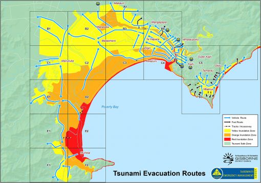
The Gisborne / Tairawhiti region is vulnerable to tsunami of any size at any time, it’s crucial that you have a plan and know what to do.
This modelling is based on a big earthquake such as an 8.9 magnitude centred in the Hikurangi subduction zone, off East Cape
If an earthquake's long or strong - get gone. Head to higher ground or as far inland as possible.
Don't wait for an official warning.
Online tsunami maps
Evacuation routes for Gisborne city

What the red, orange and yellow zones mean
Note: All zones must evacuate immediately in a Long or Strong earthquake.
Red zone = this is the highest risk zone and the first place people should evacuate from in all types of tsunami warnings (natural or official, generated locally or distant).
This zone is likely to be inundated by a tsunami generated by a distant earthquake as far off as Chile. There may be many hours before the inundation hits and no natural warning.
Orange zone = is the area evacuated in most, if not all distant and regional-source official warnings.
This zone is likely to be inundated by a tsunami generated by an earthquake as close as the Kermadec Islands. It could take more than one hour for the inundation to hit and there may be no natural warning.
Yellow zone = local threat, you will feel it and have minutes to evacuate.
A big earthquake such as an 8.9 magnitude centred in the Hikurangi subduction zone (off East Cape) will be long, strong and means get gone.
Detailed evacuation routes by grid area
No results found for ""
Evacuation areas from Muriwai to East Cape
No results found for ""