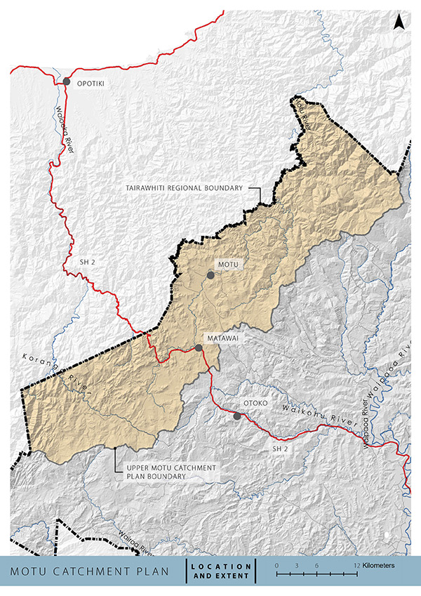
We are preparing a Mōtū Catchment Plan as part of implementing the National Policy Statement for Freshwater Management.
The Mōtū Catchment Plan will also include the adjacent Koranga River, Opato Stream and Pakihi Stream catchments within the Gisborne region. The plan will set the regulatory and non-regulatory framework for water quality and quantity within the catchment and eventually sit within the Tairāwhiti Resource Management Plan.
The Mōtū River is Gisborne’s largest upland river. It has significant ecological values, particularly in the upper reaches. The river’s water quality, aquatic ecosystem values, swimming values and the quality of its trout fishery have been gradually declining with the intensification of grazing, climate change and other land-use activities.
Plan Stop legislation may affect the timeline
The government’s Plan Stop legislation came into effect on 21 August 2025. This means that until 31 December 2027 councils can’t notify new plan changes or reviews unless they have an exemption.
This may affect the timeline and scope of the catchment plans.
Feedback
Feedback on the draft Mōtū Catchment Plan has now officially closed.
If you have any questions or concerns, you're welcome to email Principal Policy Advisor Janic Slupski on trmp@gdc.govt.nz
When developing the Mōtū Catchment Plan our aim is to:
1. Ensure the mauri and values of waterways are recognised, protected and enhanced.
2. Ensure the interests and rights of tangata whenua are reflected in the plan.
3. Ensure residents and stakeholders have opportunities to inform how water will be managed.
4. Provide clear direction for sustainable management of freshwater in the catchment.
Throughout 2021 we worked with communities to develop the content of the plan, including:
- Identifying the issues and values of waterbodies in the catchment
- Mapping Freshwater Management Units (FMU)
- Formulating objectives
- Setting targets
- Setting limits for water quality and quantity
- Outlining non-regulatory projects that support the objectives and targets
Engagement with tangata whenua
Tikanga, matauranga, kaitakitanga and the aspirations of mana whenua are essential for designing the values, objectives, limits and activities in the catchment plan.
We’re currently engaging with whānau and hapū of Te Aitanga a Mahaki to create the plan through hapu/Iwi hui and regular updates to iwi governance and representatives from hapū on the technical reference group.
Community and wider engagement
We've held community workshops with residents and whānau from the Mōtū and Matawai communities.
The Mōtū Catchment Advisory Group
The development of the Mōtū Catchment Plan will be informed by a catchment advisory group consisting of 6 members. Group members have committed to regularly attend monthly meetings to build an understanding of water quality and quantity issues in the catchment.
Members have strong connections to the Mōtū and Koranga catchments and represent a range of community perspectives. The advisory group members are:
Joanna Barbarich. Joanna has whakapapa to the Mōtū awa through her connections to Te Aitanga a Mahaki and Te Whānau a Apanui iwi. Her whānau have lived in the Mōtū, Matawai area for many generations. Joanna maintains ahi kaa as an active committee member of Matawai Marae.
Pehimana Brown (stakeholder group chair). Pene is the chair of Te Aitanga a Māhaki Trust and deputy chair of Mangatu Blocks. Pene and his family have farmed at Puha for 4 generations and his whānau marae is Tapuihikitia Marae.
BJ Holdsworth. BJ has fished in the Mōtū River for the last 36 years and also farms near to the Motu catchment. He’s a passionate trout fisherman and also runs a local hunting and fishing guiding business.
Britney Ford. Britany lives in the Motu and works as technical assistant on environmental matters for Mangatu Blocks who farm in the catchment. She has a degree in environmental science and is doing her masters research on the Mōtū River.
Henry Gaddum. Henry has recently taken over the family farm, Kotare Station, with his wife and young son. He’s on the Mōtū Catchment Group and is very interested in on-farm biodiversity and solving current issues with agriculture that the area has.
Pania King. Pania owns and farms Kiriroa Station with her husband and is chair of the Mōtū Catchment Group. The Kings are current holders of the Ahuwhenua trophy, Pania is also chair of Mōtū School and a trustee on the Whinray Reserve, Mōtū Community Centre, and Paea partnership executive group. She works at Te Puni Kōkori as an advisor for whenua Māori.
Paul Cornwall. Paul is the principal of Mōtū School and has lived, fished and hunted in the Mōtū catchment for 35 years. He's the chair of the Mōtū Community Centre.
Kerry Worsnop is the Waipaoa ward councillor for Gisborne District Council. Kerry attends the advisory group meetings in her capacity as the ward’s elected representative. She farms with her husband in the Wharekopae catchment and has been involved in the management of the Mōtū catchment project.

The Mōtū River is Gisborne’s largest upland river. It has significant ecological values particularly in the upper reaches. The river’s water quality, aquatic ecosystem values, swimming values and the quality of its trout fishery have been gradually declining with the intensification of grazing, climate changes and other land-use activities.
At the Mōtū Falls is the Whinray Scenic Reserve – the only place in the North Island where kiwi and weka co-habit. The catchment is home to Hochstetter’s Frog, Blue Duck, long tailed bat, koaro, longfin eel and a range of other threatened riverine species. The river is an important habitat for tuna – a key indicator of mauri for tangata whenua which include Te Aitanga a Mahaki, Nga Ariki Kaiputahi and Te Whanau a Apanui.
The Lower Mōtū – within the Bay of Plenty region – is subject to a water conservation order and the whole river is noted for its nationally significant trout fishery. However, 35 kilometres of the river runs through farmland in the Gisborne district above the water conservation order and the values within the farming on the extensive terrace system adjacent to the river is widespread.
The Upper Mōtū River is considered to be the single most at-risk river in the region. There are also 2 of the largest regionally significant wetlands adjacent to the headwaters. The area is the main access for trout anglers and is an international fishing destination. It’s also the gateway to the Mōtū Trails NZ Cycle Trail which commences at Mōtū Village next to the river.
Intensification of land use is the primary activity impacting on water quality that include:
- increased sedimentation from cultivation for cropping;
- increased fertiliser runoff and leaching from crop establishment;
- sediment and faecal input from stock access to the river and its tributaries from sheep, and dairy farms
- substantial drainage of ephemeral wetlands, and straightening of the river with loss of riparian vegetation and habitat.
Conversion to dairy farming is happening within the catchment with the large river terraces, and proximity to the dairy factory at Edgecumbe being favourable to the area. While currently only 2 of the region’s 5 dairy farms are located in the catchment, up to 11 further dairy farms are possible. Other parts of the catchment have recorded the largest degree of increasing intensification of stock grazing, large-scale beef, fodder crops and wintering of dairy stock is occurring.
The pumice soils on the terraces with stony soils on slopes means there’s high rates of leaching of nutrients. Water quality trends indicate that phosphate levels are increasing and data has captured large spikes of ammonia, particularly in the lower reaches.
Alongside this, septic tank maintenance in the villages of Matawai and Mōtū has been poor, and failures are increasing in winter with high rainfall in the area. State Highway 2 is a major stock transport route and there are ongoing problems with illegal discharges of stock effluent from holding tanks.
The river has a high build-up of silt and sediment on the river bed during periods of low flow. Recently algae - Phormidium - has become widespread in the catchment. Council staff suspect it's reaching a tipping point. Trout surveys undertaken by Fish and Game also indicate that the nationally significant trout fishery is in decline.
How to get involved
- Check for any open engagements - kōrero mai via our engagement portal
- Ask us a question - email the team at trmp@gdc.govt.nz
- Sign up for Council News | He Pānui - using this form.
