We began developing a Southern Tairāwhiti Catchment Plan as part of implementing the National Policy Statement for Freshwater Management 2020. However, this work is now on hold under the government's Plan Stop legislation.
The Southern Tairāwhiti Catchment flows into Hawke’s Bay / Te Mātau-a-Māui area and is known as the Wairoa and Northern Coast Catchments by Hawke's Bay Regional Council. What we do in one region affects the other and tangata whenua and community interests also span across both regions. We have been working closely with Hawke’s Bay Regional Council on this project.
Developing the catchment plan will:
- Ensure the mauri and values of waterways are recognised, protected and enhanced.
- Provide clear direction for sustainable management of freshwater in the catchment.
- Ensure residents and stakeholders have opportunities to inform how water will be managed.
- Ensure the interests and rights of tangata whenua are reflected in the plan.
Plan Stop legislation may affect the timeline
The government’s Plan Stop legislation came into effect on 21 August 2025. This means that until 31 December 2027 councils can’t notify new plan changes or reviews unless they have an exemption.
This may affect the timeline and scope of the catchment plans.
Catchment advisory group
The development of the Southern Tairāwhiti Catchment Plan will be informed by an advisory group consisting of 13 members. Group members have committed to regularly attend monthly meetings to build an understanding of water quality and quantity issues in the catchment.
Members have strong links to the catchment area and represent a range of community perspectives.
- Marlene Skeet
- Kerry Proctor
- Bella Hawkins
- Jazmine Burgess
- Topsy Steele
- Bryan McCavana
- Soraya Pohatu-Stone
- Mayana Daniels
- Wings Waihi
- Tangiwai Wilson
- Jess Kawenga
- Charlie Baty
- Samuel Lewis
The advisory group members are:
Area covered by the catchment plan
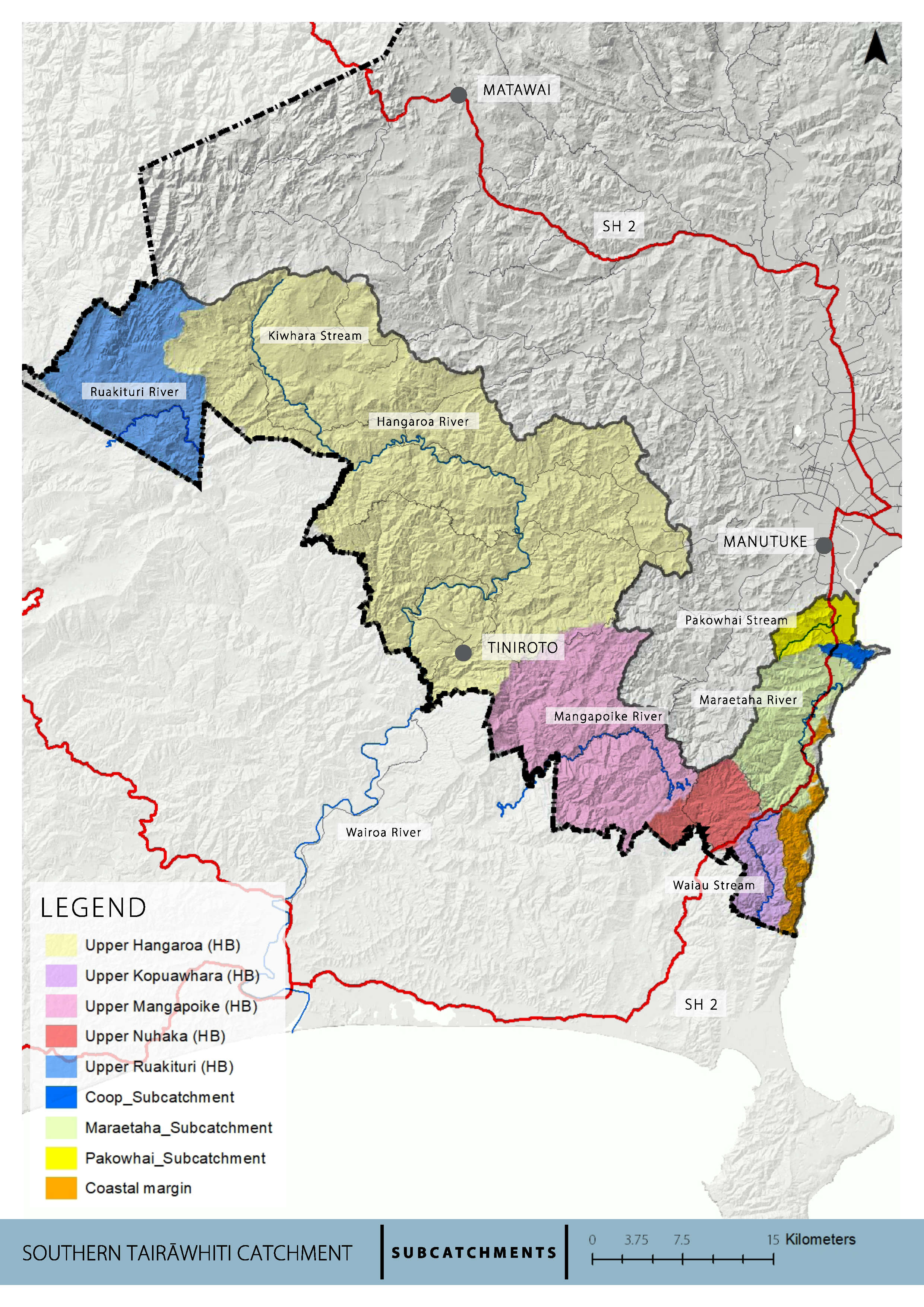
The Southern Tairāwhiti Catchment Plan area includes catchments that flow towards Hawke’s Bay Te Mātau-a-Māui and into Gisborne Tairāwhiti.
These catchments include:
- The Ruakituri, Hangaroa, Mangapoike and Nūhaka River and Kopuawhara Streams, which all form the south-western boundary of Tairāwhiti and flow into Hawke’s Bay-Te Mātau-a-Māu.
- The Pakowhai Stream that flows into Wherowhero Lagoon.
- The Maraetaha River beside State Highway 2 before flowing to the coast.
- Several smaller catchments located along the coastal margin between the Maraetaha catchment, State Highway 2 and the end of Mahanga Road (in Wairoa), including the Wharekakaho, Waikara, Tikiwhata and Hauraki Streams and streams with un-documented names.
Their total combined catchment area in the Gisborne Tairāwhiti region is 1,270km2, the largest catchment area being the Hangaroa (726km2), followed by Mangapoike (185km2) and Ruakituri (130km2).
Catchments map
Timeline for the catchment plan
By law, we must have completed our catchment planning development for the whole region by the end of 2027.
14 April 2025 - Community Hui at the Muriwai School Hall asking for applications to the Southern Catchment Advisory Group.
15 April 2025 - Community Hui at the Tiniroto Community Hall asking for applications to the Southern Catchment Advisory Group.
5 May 2025 - Applications to the Southern Catchment Advisory Group closed.
9 May 2025 - Catchment Advisory Group members announced.
March - December 2025: Series of meetings with the Southern Advisory Group
Plan Stop legislation may affect the timeline for this plan.
Engaging on freshwater
Freshwater outcomes need to reflect community aspirations. The NPS for Freshwater Management requires engagement throughout the National Objectives Framework (NOF) process and provides for community and tangata whenua involvement in implementing the NOF and decision-making.
Every regional council must engage with communities and tangata whenua to determine how Te Mana o te Wai applies to water bodies and freshwater ecosystems in the region. Te Mana o te Wai encompasses 6 principles relating to the roles of tangata whenua and other New Zealanders in the management of freshwater.
Links
Several iwi and hapū rohe intersect and overlap in the Southern Tairāwhiti Catchment area. This includes Te Aitanga a Māhaki, Te Whānau a Kai, Rongowhakaata, Ngai Tāmanuhiri, Ngāi Tūhoe, Ngāti Kahungunu ki Te Wairoa, Ngāti Rakaipaaka, Ngāti Ruapani and Rongomaiwahine.
Tikanga, mātauranga, kaitiakitanga and the aspirations of tangata whenua are essential for designing the values, objectives, limits and activities in the catchment plan.
Engagement with tangata whenua in the Southern Tairāwhiti Catchment is central to the catchment planning process.
We'll hold community meetings with residents and whānau from the catchment. All meetings are open to everyone.
We will update this section once dates for community engagement are finalised.
Overall community engagement will start March/April 2025.
We will set up an advisory group made up of tangata whenua and community members. Group members will represent people living and working in the catchment, working closely with Council in the catchment plan. The Advisory Group will:
- explore what Te Mana o te Wai means to the community
- identify issues and values of waterbodies in the catchment
- map freshwater management units (FMU)
- formulate objectives
- set targets
- set limits for water quality and quantity
- identify actions that support achieving objectives and targets
How to get involved
- Check for any open engagements - kōrero mai via our engagement portal
- Ask us a question - email the team at service@gdc.govt.nz
- Sign up for Council News | He Pānui - using this form.